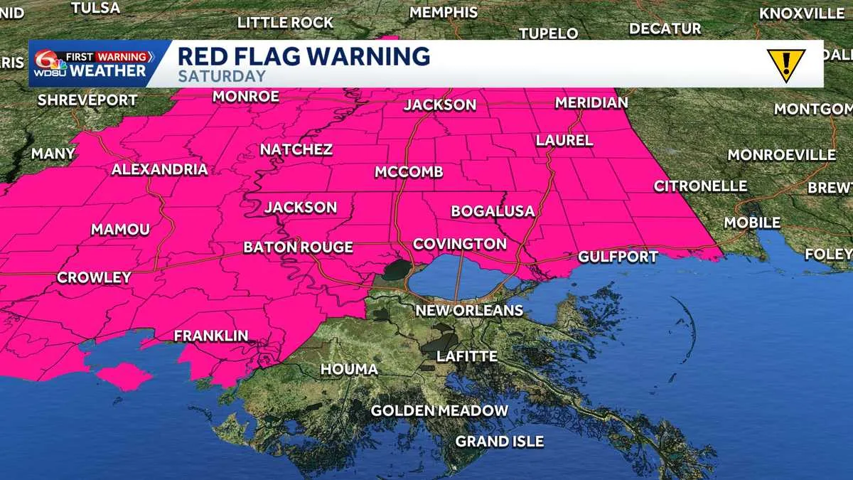
NEW ORLEANS, LA — The National Weather Service in New Orleans has issued a Red Flag Warning for all of southern Mississippi and parts of southeast Louisiana on Saturday, citing critical fire weather conditions. The warning runs from 9 a.m. to 8 p.m. CDT and replaces an earlier Fire Weather Watch.
A cold front moving through the region is expected to bring very dry air, with relative humidity dropping into the low-to-mid 30 percent range. With northerly winds of 10 to 20 mph and gusts as high as 30 mph, any fire that starts could spread quickly.
Officials are also tracking a separate Wind Advisory that begins Friday afternoon and continues into Saturday. Together, the alerts create a weekend period of elevated weather concerns for residents across the region.
Parishes and counties included in the red flag warning
The warning covers a wide area in Louisiana, including Ascension, Assumption, East Baton Rouge, East Feliciana, Iberville, Livingston, Pointe Coupee, St. Helena, St. James, St. Tammany, Tangipahoa, Washington, West Baton Rouge and West Feliciana parishes.
In Mississippi, the affected counties include Amite, Hancock, Harrison, Jackson, Pearl River, Pike, Walthall and Wilkinson. The National Weather Service says the combination of dry vegetation, low humidity, warm temperatures and gusty winds creates an environment where fire behavior could become extreme.
The warning is designed to signal that conditions are either happening now or are expected soon enough to require immediate caution. That means even a small ignition could become difficult to control without fast response.
Why officials say the fire risk is unusually high
Fire weather warnings are issued when the atmosphere becomes favorable for rapid fire spread. In this case, the biggest concerns are dry air and strong north winds arriving at the same time that vegetation can dry out quickly.
Relative humidity in the low-to-mid 30 percent range may not sound extreme on its own, but paired with wind gusts up to 30 mph it can make flames move faster and embers travel farther. The National Weather Service says that combination can support dangerous fire growth.
The region’s warning follows the movement of a cold front, which is helping push the dry air into place. Residents are being urged to treat outdoor flames, sparks and heat-producing equipment as serious risks during the warning period.
Safety steps residents are being urged to follow
Weather officials are asking people to avoid outdoor burning during the warning period, including yard debris, brush and trash fires. Even controlled burning can become hazardous when winds are strong and humidity is low.
They also advise fully extinguishing cigarettes and other smoking materials, and never tossing them outside or from a vehicle. Campfires and grills should be doused with water until completely cold before being left unattended.
People are also being told to avoid using lawn mowers or power tools on dry grass during the hottest, windiest part of the day. Trailer safety chains should not drag on roadways, since sparks can become an ignition source.
Wind advisory begins Friday afternoon across major metro areas
The National Weather Service has also issued a Wind Advisory for portions of southeast Louisiana and southern Mississippi beginning at 4 p.m. Friday and lasting through 3 p.m. CDT Saturday. During that time, sustained northerly winds of 15 to 25 mph are expected, with gusts reaching up to 35 mph.
The advisory includes the greater Baton Rouge and New Orleans metropolitan areas, the Northshore and coastal parishes in Louisiana. In Mississippi, it extends across Pike, Pearl River, Hancock, Harrison and Jackson counties.
Forecasters say these winds could blow around unsecured outdoor items such as patio furniture, garbage cans and seasonal decorations. Loose property should be secured before the strongest gusts arrive.
Drivers and utility customers should prepare for disruptions
Windy conditions may make travel difficult, especially for drivers of high-profile vehicles such as semi-trucks, vans and SUVs. Crosswinds on elevated bridges and open highways can create steering problems, particularly when gusts spike unexpectedly.
The National Weather Service also warns that branches could be knocked down, which could lead to minor power outages in some areas. Residents are being encouraged to prepare for brief disruptions into Saturday afternoon.
Officials recommend taking precautions Friday afternoon before conditions worsen. That includes securing outdoor property, checking items that could become airborne and planning for possible interruptions to power and travel.