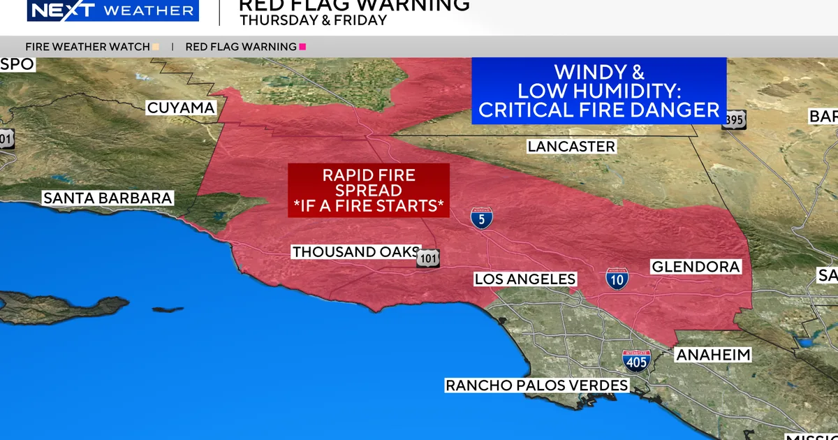
LOS ANGELES, CA — A Red Flag Warning is in effect for parts of Southern California as forecasters say a moderate to strong Santa Ana wind event is expected to push fire danger higher through Saturday.
The National Weather Service says the combination of dry heat and gusty offshore winds could allow any new fire to spread quickly. The warning covers most of Los Angeles and Ventura counties and remains in place through 8 p.m. Saturday.
Weather officials are urging residents to be extra careful with anything that could spark a wildfire while the warning lasts.
Strong offshore winds are expected to peak Thursday and Friday
The National Weather Service says northeast to east winds could blow at 20 to 40 mph, with gusts reaching 50 to 70 mph in some areas. The strongest conditions are expected from Thursday afternoon through Friday afternoon.
Forecasters say the winds will follow a familiar Santa Ana pattern, building a few hours before dawn, peaking in the mid-morning, then easing somewhat later in the day and evening. That timing can make fire behavior harder to predict, especially when winds rise quickly after calm overnight conditions.
Those wind shifts are one reason the agency is warning people to stay alert over the next several days, particularly in foothill and canyon communities that often see the strongest effects from Santa Ana events.
Hot temperatures will add to the fire weather risk
The winds are not the only concern. Temperatures are expected to climb as the week goes on, adding more fuel to already dangerous fire weather conditions.
On Friday, valleys and coastal areas are forecast to reach the upper 80s and 90s, with some locations possibly hitting 100 degrees. That kind of heat can dry out vegetation and make it easier for flames to move rapidly if a fire starts.
In Southern California, the overlap of heat, dry air and strong wind often creates a short window for dangerous fire growth, which is why officials are treating this event as a serious threat.
What a Red Flag Warning means for residents
A Red Flag Warning is issued when critical fire weather conditions are happening now or are expected soon. The alert is meant to warn communities that a fire could start easily and spread fast under the forecast conditions.
During a warning, weather officials urge people to use extreme caution with anything that could spark a wildfire. That includes outdoor burning, machinery that can throw sparks and any other activity that could ignite dry brush.
For many residents, the warning also serves as a reminder to prepare for fast-changing conditions, especially in neighborhoods near open space, canyons or wildland areas.
Los Angeles and Ventura counties face the highest concern
The warning area includes most of Los Angeles and Ventura counties, two regions that regularly face elevated fire danger during Santa Ana wind events. The National Weather Service says the warning will remain active until 8 p.m. Saturday unless conditions change.
These counties contain dense neighborhoods as well as large stretches of dry terrain, which can make wildfire response more complicated if a fire starts during windy weather. Strong gusts can push flames quickly through brush and make it harder for firefighters to control an emerging blaze.
Officials have not said that any fire is burning now, but the warning reflects how quickly conditions could become dangerous if one does ignite.
Fire season concerns rise as autumn winds return
Santa Ana winds are a familiar autumn hazard in Southern California, often arriving with dry air and warm temperatures that can turn a small spark into a major emergency. This week’s forecast fits that pattern, with stronger winds expected first and hotter weather following close behind.
As the event unfolds, forecasters are watching both the wind speeds and the temperature outlook to see how long the elevated danger lasts. Even after the strongest winds ease, hot and dry conditions can keep fire risk high.
For residents across the warning area, the next several days will likely be a test of how quickly the region can move from seasonal comfort to critical fire weather.